Queen Elizabeth National Park
Queen Elizabeth National Park, Uganda – Kazinga Channel Wildlife Safaris, Tree-Climbing Lions, Crater Lakes, Chimpanzee Tracking in Kyambura Gorge and the Albertine Rift’s Most Complete Savannah Ecosystem
Queen Elizabeth National Park is one of Africa’s most extraordinary wildlife landscapes—a place where savannahs stretch toward the shimmering waters of the Kazinga Channel, rainforest gorges protect rare chimpanzees, crater lakes glint beneath volcanic hills, and tree-climbing lions rest on ancient fig trees. Located in western Uganda within the Albertine Rift, this 1,978 km² protected area is one of the continent’s most biodiverse ecosystems, home to more than 95 mammal species, over 610 bird species, and a stunning array of habitats including woodlands, wetlands, riverine forests, crater fields, savannah plains, and lake shorelines. Its accessibility, beauty, and richness make it the most visited national park in Uganda and one of East Africa’s most complete safari destinations.
Beyond the iconic wildlife sightings, the park reveals intricate ecological networks shaped by volcanic forces, tectonic shifts, seasonal flooding, complex predator–prey dynamics, and the constant flow of life along the Kazinga Channel. This unique combination of savannah, rainforest, wetland, and volcanic geology makes Queen Elizabeth National Park a living laboratory of biodiversity—one where every valley, crater, riverbank, and gorge tells a story of evolution, adaptation, survival, and cultural history.
Overview
Queen Elizabeth National Park stands as one of Uganda’s flagship conservation areas, offering a level of ecological diversity rarely seen in a single protected landscape. Its habitats span open plains, wooded savannahs, riparian forests, papyrus swamps, and dense tropical forests, resulting in a remarkably high species richness. The park’s location at the crossroads of East African savannah and Central African rainforest regions allows both savannah mammals and forest specialists to coexist within the same protected zone.
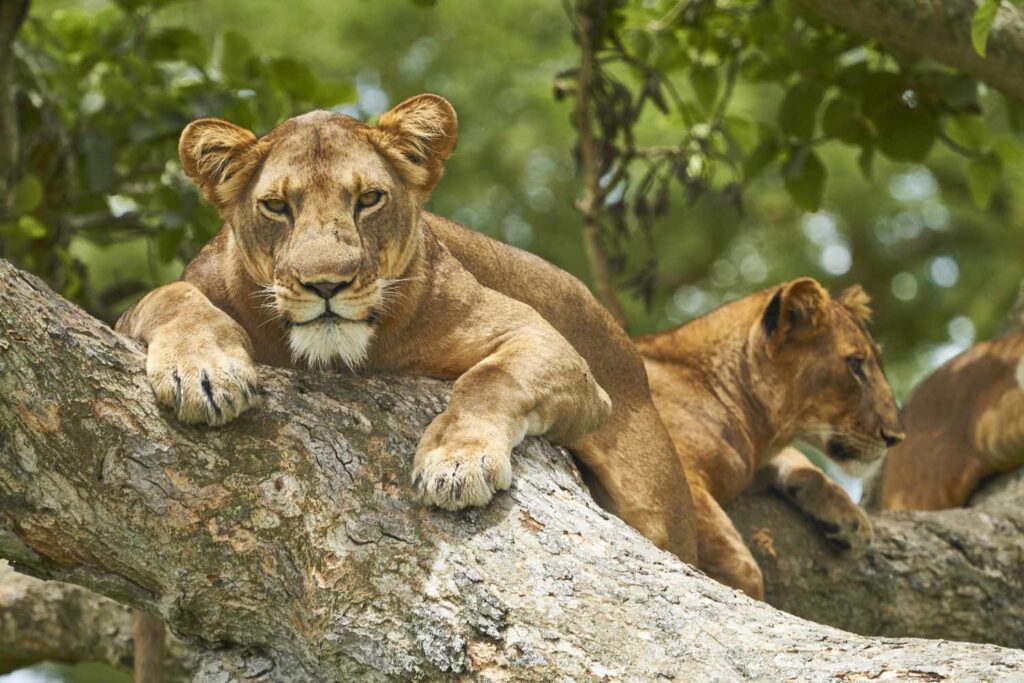
Game drives on the Kasenyi Plains reveal classic African savannah scenes—lions trailing herds of Uganda kob, hyenas patrolling the grasslands, and elephants moving across the horizon. In contrast, the lush greenery of Kyambura Gorge shelters a remnant chimpanzee population that survives in a “forest island” surrounded by grassland. The Kazinga Channel boat cruise, one of the park’s signature experiences, offers unrivaled wildlife viewing as elephants, hippos, crocodiles, buffalo, and hundreds of waterbirds gather along the shoreline. The Ishasha Sector’s unusual tree-climbing lions, the crater lakes region’s geological wonder, and the Rwenzori Mountains’ dramatic backdrop complete this incredibly diverse tourism landscape.
Location, Size and Key Facts
Set within the western branch of the Great Rift Valley, Queen Elizabeth National Park occupies a prime position in southwestern Uganda. Its mosaic of landscapes stretches from the foothills of the Rwenzori Mountains to the vast plains bordering Lake Edward. The area serves as an ecological corridor connecting Kibale Forest National Park to the north and Bwindi Impenetrable National Park to the south, enabling seasonal wildlife movement and supporting broader conservation networks in the region.
- Country: Uganda
- Region: Western Uganda
- Coordinates: Approx. 0.2° S, 29.9° E
- Area: ~1,978 km²
- Established: 1952 (renamed in 1954)
- Altitude: 910–1,391 meters above sea level
- Nearest Cities: Kasese, Mbarara, Bushenyi
- Key Sectors: Kasenyi Plains, Mweya Peninsula, Ishasha Sector, Kyambura Gorge, Maramagambo Forest, Lake George, Lake Edward, Katwe Explosion Craters
Geology – Rift Valley Forces, Crater Fields and Ancient Volcanoes
The geology of Queen Elizabeth National Park is a dramatic testament to the power of the Great Rift Valley. The park lies within the Albertine Rift, where tectonic plates continue to pull apart, shaping the landscape with fault lines, uplifted blocks, and collapsed basins. The region’s most striking geological features are its volcanic explosion craters—formed by violent eruptions thousands of years ago—and today they create a breathtaking mosaic of crater lakes, steep-walled basins, and circular grassland depressions.
More than 80 craters are spread between the Kabatoro Gate, Katwe, and the Mweya Peninsula. These craters vary from saline lakes, such as Lake Katwe (used for centuries for salt extraction), to lush vegetated craters that provide grazing areas for wildlife. Each crater has its own microhabitat shaped by mineral composition, water levels, soil chemistry, and surrounding vegetation.
The Kyambura Gorge, another geological marvel, was formed as the Kyambura River cut sharply through layers of volcanic ash and sediment. This rainforested canyon is up to 100 meters deep and acts as a refuge for primates and forest species isolated from the surrounding savannah. The steep escarpments of the Rift Valley and the distant peaks of the Rwenzori Mountains complete one of Africa’s most scenic wildlife backdrops.
Geography and Landscape Diversity
Queen Elizabeth National Park is a landscape of remarkable contrasts. Open golden plains merge into dense woodlands; crater lakes sit next to rocky ridges; papyrus wetlands line the shores of vast Rift Valley lakes; and tropical forests hide in deep canyons. Each of these landscapes supports a distinct ecological community.
- Kasenyi Plains: The prime safari zone, known for lions, kob breeding grounds, and expansive savannah.
- Mweya Peninsula: A scenic promontory between Lake Edward and the Kazinga Channel, offering panoramic views.
- Katunguru Bridge: A strategic hydrological point where Lake George drains into the Kazinga Channel.
- Ishasha Sector: Home to the famous tree-climbing lions and herds of topi and buffalo.
- Katwe Crater Lakes: Saline and freshwater craters rich in minerals and birdlife.
- Kyambura Gorge: A deep tropical forest canyon sheltering chimpanzees.
- Mitumbe Hills: Rising along the Congo border, overlooking the Ishasha plains.
- Kikorongo Plains: Known for volcanic soils and seasonal grazing migrations.
Climate and Weather Patterns
The park enjoys a warm, tropical savannah climate moderated by its elevation and proximity to the Rwenzori Mountains. Its weather patterns are influenced by lake breezes, Rift Valley winds, and orographic rainfall from the mountains. While the region receives substantial rainfall, the savannah remains open due to seasonal fires and herbivore grazing pressure.
- Long Dry Season: June–September – best game-viewing as animals concentrate around water.
- Short Dry Season: December–January – clear skies and excellent photography conditions.
- Long Rains: March–May – lush scenery and abundant birdlife.
- Short Rains: October–November – dramatic skies and active wildlife.
Temperatures generally range from 27–29°C during the day, dropping to 15–18°C at night. Rainfall averages between 750–1,250 mm annually, with higher amounts falling near the Rwenzori foothills and lower amounts toward Ishasha.
Hydrology – The Kazinga Channel and Lake Ecosystem
Water defines Queen Elizabeth National Park’s ecological dynamics. The Kazinga Channel is the most important hydrological artery, sustaining vast concentrations of large mammals and aquatic species. This natural channel connects the shallow, freshwater Lake George to the deep Rift Valley Lake Edward, creating a constant flow of nutrient-rich water that supports abundant fish populations and attracts wildlife throughout the year.
- Kazinga Channel: One of Africa’s greatest wildlife corridors, hosting thousands of hippos and large herds of buffalo and elephant.
- Lake Edward: Supports diverse fish species, crocodiles, and migratory waterbirds.
- Lake George: Fed by the Rwenzori Mountains; shallow, nutrient-rich waters drive biological productivity.
- Crater Lakes: Many are extremely saline, forming unique ecosystems with algae, flamingos, and specialized flora.
- Kyambura River: Maintains the forest ecosystem within Kyambura Gorge.
Papyrus wetlands along the lakeshore serve as breeding grounds for fish, nesting sites for rare birds like the shoebill, and refuge for aquatic antelope such as the sitatunga. These wetlands also play crucial roles in water purification and flood regulation.
Ecosystems and Habitat Diversity
The extraordinary ecological diversity in Queen Elizabeth National Park arises from the varied topography, soils, rainfall patterns, and hydrological systems. The main ecosystems include:
- Savannah Grasslands: Home to lions, elephants, kobs, and hyenas.
- Acacia Woodlands: Ideal habitat for buffalo, elephants, and Ishasha’s tree-climbing lions.
- Papyrus Swamps: Nursery grounds for fish and habitat for shoebills and papyrus gonoleks.
- Riverine Forests: Found along the Kazinga Channel and Kyambura River; home to primates and forest birds.
- Tropical Lowland Forests: Maramagambo Forest shelters bats, colobus monkeys, and rare bird species.
- Crater Lakes Ecosystem: Unique mineral-rich basins supporting flamingos and algae.
Vegetation – Savannahs, Papyrus Wetlands, Forests and Crater Habitats
Vegetation in the park reflects the interplay between rainfall, soil type, herbivore populations, and fire regimes. Savannah grasslands dominate much of the park and include elephant grass, Themeda triandra, Sporobolus, Setaria, and patches of short grass favored by grazers.
- Acacia species: Umbrella acacia, Acacia gerrardii, and Vachellia seyal.
- Papyrus: Cyperus papyrus around Lake George and the Kazinga Channel.
- Forest species: Ficus natalensis, Albizia, Celtis, and Cordia in Kyambura Gorge.
- Crater vegetation: Halophytes adapted to saline soils, fig forests on volcanic slopes.
Elephants play a major role in shaping vegetation by uprooting trees, dispersing seeds, and creating pathways through thickets. This form of natural landscape engineering increases habitat diversity.
Wildlife of Queen Elizabeth National Park
Large Mammals
- African Elephant: Widespread across the Kikorongo plains, Mweya Peninsula, and Kazinga Channel.
- African Lion: Strong populations, especially in Kasenyi; Ishasha lions climb fig trees.
- Leopard: Often seen near Mweya and along the Maramagambo edge.
- Buffalo: Massive herds around Kazinga Channel.
- Hippos: One of the world’s largest populations.
- Spotted Hyena: Active in early morning and late evening.
- Uganda Kob: The park’s dominant antelope and primary lion prey.
- Topi, Bushbuck, Waterbuck: Abundant in Ishasha and Maramagambo fringes.
Primates
- Chimpanzees in Kyambura Gorge
- L’Hoest’s monkey
- Black-and-white colobus
- Vervet monkeys
- Olive baboons
Birdlife – Over 610 Species
The park is ranked among the top birding destinations in the world. Its mix of savannah, forest, wetland, and lake habitats supports an impressive variety of birds—from raptors and shorebirds to Rift Valley endemics and Palearctic migrants.
- Shoebill stork
- African fish eagle
- Pied and malachite kingfishers
- Martial eagle
- Flamingos (Lake Munyanyange)
- Grey crowned crane
- Papyrus gonolek
- Great white pelican
Birding Hotspots
- Kazinga Channel: Best for waterbirds, skimmers, storks, and pelicans.
- Katwe–Bunyampaka Lakes: Flamingos during certain seasons.
- Maramagambo Forest: Forest robins, sunbirds, greenbuls.
- Kasenyi Plains: Raptors, bustards, and grassland specialists.
- Papyrus Wetlands: Shoebill, papyrus canary, and water rails.
Reptiles and Amphibians
- Nile crocodile
- African rock python
- Monitor lizards
- Puff adder
- Tree frogs and wetland amphibians
Wildlife Behavior and Seasonal Movements
- Lions: Follow Uganda kob breeding grounds on Kasenyi Plains.
- Ishasha Lions: Rest in fig trees to avoid heat and biting insects.
- Elephants: Move between Lake Edward, Mweya Peninsula, and Kikorongo plains.
- Hippos: Graze mostly at night and return to water at sunrise.
- Bird migrations: Palearctic migrants arrive between October and April.
Indigenous Communities and Cultural Heritage
The park is surrounded by diverse communities whose cultures and livelihoods have been shaped by this landscape for centuries. The most notable groups include the Basongora pastoralists, Bakiga agriculturalists, and fishing communities around Lakes Edward and George.
- Salt Mining at Lake Katwe: A tradition dating back at least 700 years.
- Fishing Communities: Hamukungu, Kasenyi, Katunguru.
- Pastoral Traditions: Basongora cattle herding practices.
- Cultural Performances: Music, dance, storytelling.
Conservation Importance
- Protects key populations of big mammals.
- Critical bird habitat within the Albertine Rift.
- Important wildlife corridor linking Bwindi, Kibale, and Virunga landscapes.
- Conserves unique crater and wetland ecosystems.
Conservation Projects and Research Programs
- Elephant collaring to track movements and reduce conflict.
- Lion monitoring and community coexistence programs.
- Chimpanzee research in Kyambura and Kalinzu.
- Wetland bird counts and migratory bird studies.
- Anti-poaching canine units and ranger patrols.
- Beekeeping and community livelihood projects.
Threats and Management Challenges
- Human–wildlife conflict (especially elephants and predators).
- Bushmeat hunting.
- Lion poisoning incidents linked to livestock attacks.
- Illegal fishing and wetland pressure.
- Habitat encroachment and land-use change.
- Climate-change-related flood and drought cycles.
Tourism Activities
- Game Drives: Kasenyi, Mweya, Ishasha.
- Kazinga Channel Boat Cruise: Best for hippos, birds, elephants.
- Chimpanzee Trekking: Kyambura Gorge and Kalinzu Forest.
- Lion Tracking Experience: UWA-guided research tourism activity.
- Nature Walks: Maramagambo, crater lakes, Mweya.
- Birdwatching: One of Africa’s greatest birding parks.
- Salt Mining Tour: Lake Katwe cultural experience.
- Cultural Encounters: Fishing villages and pastoral communities.
Safety and Practical Tips
- Hippos are extremely dangerous—avoid lakeshores at night.
- Stay in vehicles during game drives.
- Use 4×4 vehicles in rainy seasons.
- Carry sufficient drinking water, sunscreen, and insect repellent.
- Obey ranger instructions during boat cruises.
Access and How to Get There
- By Road: Kampala–Masaka–Mbarara route (6–7 hours).
- By Air: Daily flights to Mweya or Kasese with Aerolink Uganda.
Permits and Regulations
- Park entry fees paid to UWA.
- Chimpanzee trekking permits required.
- Night drives require ranger accompaniment.
- No drone use without special approval.
Accommodation
- Luxury: Kyambura Gorge Lodge, Ishasha Wilderness Camp, Mweya Safari Lodge.
- Mid-range: Elephant Plains, Engiri Lodge, Twin Lakes Safari Lodge.
- Budget: Community lodges, park bandas.
- Campsites: Public and special campsites around Mweya and Ishasha.
Best Time to Visit
- June–September: Peak wildlife viewing.
- December–January: Clear skies and dry weather.
- March–May: Lush scenery; birding peak.
- October–November: Good photography with dramatic skies.
Why Queen Elizabeth National Park Is Unique
Queen Elizabeth National Park is unmatched in its diversity of landscapes, wildlife, ecosystems, and cultural heritage. It is one of the few places in Africa where you can see tree-climbing lions, chimpanzees, huge buffalo herds, crater lake panoramas, and hippo-filled waterways all within a single protected area. Its blend of Rift Valley geology, volcanic history, wetland systems, forested gorges, open plains, and rich biodiversity makes it a true African wilderness masterpiece.
For travelers, conservationists, and nature lovers, Queen Elizabeth National Park offers an immersive experience—one where every sunrise brings new possibilities and every landscape tells a story shaped by millions of years of natural history. It remains one of Africa’s greatest wildlife destinations and a cornerstone of Uganda’s natural heritage.