Tsingy de Bemaraha National Park
Tsingy de Bemaraha National Park, Madagascar – Complete Travel Guide to the Stone Forest, Karst Pinnacles, Lemurs & UNESCO World Heritage Wilderness
Overview – A Landscape Like Nowhere Else on Earth
Tsingy de Bemaraha National Park is one of the most visually astonishing places on Earth — a wilderness sculpted from limestone needles, towering pinnacles, hidden caves, narrow canyons, rope bridges and vertical labyrinths where only the sure-footed survive. Its Malagasy name, “Tsingy,” meaning “where one cannot walk barefoot,” is a poetic warning: this landscape is made of razor-sharp stone blades shaped over millions of years by water, wind and corrosion.
In this UNESCO-protected universe of rock and forest, evolution took its own path. Species that became isolated among separate karst towers evolved independently, creating unique lemurs, reptiles, frogs, birds and invertebrates — many of which exist nowhere else on the planet. For scientists, photographers, adventure travelers, geologists and naturalists, Tsingy de Bemaraha is a once-in-a-lifetime destination that merges spectacular scenery with evolutionary wonder.
Quick Facts at a Glance
- Location: Melaky Region, Western Madagascar
- Protected Status: National Park (IUCN Category II) + Strict Nature Reserve (IUCN Ia)
- Park Size: ~723.4 km² (within the larger UNESCO World Heritage protected zone)
- UNESCO World Heritage Inscription: 1990 (Strict Nature Reserve), park framework expanded 1997 & reinforced in 2011
- Ecoregion: Western Dry Deciduous Forest & Karst Plateau
- Main Highlights: Grand Tsingy, Petit Tsingy, Manambolo Gorge & endemic wildlife
- Best Visiting Season: June to November (dry & accessible)
UNESCO & Protection Status
The northern section of Bemaraha was declared a Strict Nature Reserve long before modern tourism existed, later recognized globally when UNESCO granted World Heritage status in 1990 due to its extraordinary karst formations and biodiversity. To balance visitor demand with ecological protection, the southern section was officially designated as Tsingy de Bemaraha National Park in 1997, allowing controlled tourism access while preserving the integrity of the larger protected complex. A final consolidation in 2011 strengthened boundaries, enhancing protection for forests, wildlife populations and karst ecosystems.
Location & Landscape
The Bemaraha Plateau stretches across western Madagascar like a serrated backbone, almost 100 km long and between 10–40 km wide. This remote region lies mostly within the Antsalova District, bordered by stretches of western dry forest, riverine vegetation, seasonal marshlands and sweeping limestone canyons. Elevation varies from canyon floor to plateau ridge — sometimes climbing more than 300–400 meters in steep limestone walls.
From a distance, the park looks like a petrified forest. Up close, the detail is mesmerizing: limestone towers split into vertical blades; narrow ridges sharp as iron; deep chasms hidden between rock walls; sun-baked summits forming a jagged skyline. The deeper one travels into the Tsingy, the more surreal the world becomes — like walking inside an ancient cathedral made of stone.
Geology – How the Tsingy Were Formed
The landscape of Tsingy de Bemaraha is a geological masterpiece formed over 150–200 million years. The region was once submerged beneath a shallow Jurassic sea where limestone accumulated layer by layer. After tectonic uplift raised the plateau above sea level, centuries of rainfall, mineral erosion and underground water flow dissolved and fractured the limestone, carving fissures, sinkholes and subterranean caverns. Over millions more years, the surface stone sharpened into pinnacles while hidden river systems sculpted vast underground passages.
Few places on Earth demonstrate tropical karst evolution as dramatically and beautifully as Bemaraha. The result is one of the largest and most intimidating vertical rock labyrinths ever known — an outdoor planetarium of stone needles rising up to 120 meters high.
Climate & Hydrology
The park experiences two main seasons — a long dry season (June–November) and a wetter rainy season (December–April). Rainfall tends to be concentrated within a few months, flooding canyons, refreshing vegetation, feeding underground channels and drenching dry forests back into life. During the dry months, vegetation recedes, river levels fall, and animals move toward permanent springs, streams and ravine shade corridors.
The Manambolo River is the ecological lifeline of the park. In the gorge zone, cliffs rise dramatically above narrow water channels where boat journeys reveal caves, bats, crocodile habitats and riverbank forest life. These hydrological patterns act as seasonal engines — driving plant flowering, leaf shedding, lemur movement, amphibian breeding cycles and predator activity.
Ecosystems & Vegetation Zones
Though superficially rocky, Tsingy de Bemaraha contains one of the most complex dry forest ecosystems in Madagascar. With an estimated **430–800+ plant species**, it is a botanical powerhouse of endemism. Each geological pocket forms a new growing environment — some extremely dry and sun-bleached, others cool, shaded and humid.
- Pinnacle Summits: Severe exposure, shallow soil pockets & high heat — home to succulents, pachypodium species, drought-hardy shrubs & wax-coated leaves.
- Canyon Interiors: Humid & shaded “oases” containing ferns, vines, mosses, orchids and rare ravine-loving shrubs.
- Plateau Forest: Western deciduous woodland with canopy species dropping leaves in dry season to conserve water.
- Riparian Corridors: Thick riverbank vegetation, lush gallery forests & seasonal wetland meadows along Manambolo Valley.
- Subterranean Ecosystems: Cavern fungi, troglobitic invertebrates & bat colonies dependent on constant humidity.
The contrast is dramatic — walk from blistering rock to dripping green canyon and it feels like crossing biomes in minutes. This ecological fragmentation is the engine behind Tsingy’s wild evolutionary creativity.
Wildlife of Tsingy de Bemaraha
Tsingy de Bemaraha is less about quantity and more about rarity — many species here exist nowhere else. Isolation among karst towers helped drive speciation, especially in lemurs, reptiles and amphibians. Wildlife observation requires patience, but it rewards with world-class sightings of animals uniquely adapted to a vertical stone world.
Lemurs & Mammals
The park supports **11–13 lemur species**, including:
- Decken’s sifaka — snow-white forest dancer that leaps across pinnacle gaps like a living trapeze act.
- Bemaraha woolly lemur (Avahi cleesei) — discovered recently, among the world’s rarest lemurs.
- Sportive lemurs, brown lemurs, mouse lemurs & dwarf lemurs — several nocturnal species thrive at night.
Mammals also include fossa — Madagascar’s only major carnivore capable of hunting lemurs among rock towers — alongside Malagasy civets, tenrecs, mongoose species and cave-roosting bat colonies. Each mammal here is a survival specialist.
Birds
The park hosts **90–94 bird species**, making it a key birding destination. Top species:
- Madagascar fish eagle — critically endangered, rarely seen, symbol of conservation importance.
- Tsingy wood rail — range-restricted, living only among Bemaraha’s unique ravines.
- Vangas, herons, kestrels, bee-eaters, couas, harrier hawks, kingfishers & river-edge specialists.
Birdwatching is strongest early morning or along the Manambolo River where visibility opens across canyon mouths.
Reptiles, Amphibians & Invertebrates
Reptile diversity in the park is exceptional — with **~66 species** including leaf-tailed geckos, ground geckos, plated lizards, skinks and snakes. One of the most iconic species is the armored Brookesia perarmata chameleon — tiny yet prehistoric in appearance.
Amphibians (around **22 species**) breed in isolated rain pools, hidden depressions and seasonal canyon runoff. Invertebrates here are barely catalogued — many species likely remain undiscovered due to the difficulty of accessing narrow fissures and caves. This unexplored diversity is one reason Tsingy remains a frontier laboratory for global biological research.
Conservation Value & Why the Park Matters
Tsingy de Bemaraha protects one of **Earth’s most unique karst landscapes**, an evolutionary engine for species seen nowhere else. It safeguards western dry deciduous forest — one of Madagascar’s most threatened habitats — while protecting lemur populations, predator dynamics, reptile endemism and critical underground water networks. Without the park, most of these species would vanish.
The region also stabilizes hydrology and climate around the Manambolo watershed, preventing erosion and maintaining groundwater that sustains communities downstream. Every hectare protected here represents millions of years of Earth history and a future source of scientific discovery.
Threats & Ongoing Conservation Challenges
Despite its isolation, Tsingy is not immune to threat. Primary pressures include:
- Slash-burn agriculture & forest fires fragmenting dry deciduous woodland.
- Poaching of lemurs & reptiles affecting already fragile species numbers.
- Illegal settlement & rice paddy expansion along park edges where land pressure increases.
- Climate shifts altering rainfall timing & shrinking moisture refuges.
Conservation success depends on sustainable tourism income, fire-management strategies, anti-poaching patrols and community partnerships that incentivize protection instead of extraction. With proper stewardship, Tsingy remains a globally irreplaceable refuge.
Research & Monitoring Programs
Scientists consider Tsingy one of Madagascar’s most exciting biodiversity frontiers. New species of frogs, geckos, cave invertebrates and even plants continue to be recorded, emphasizing how little of the region has been studied thoroughly. Speleologists map underground channels; primatologists track lemur movement; botanists analyze microhabitats that differ from pinnacle to pinnacle like islands in the sky.
Future research priorities include:
- Lemur genetics & behavioral ecology across karst fragmentation
- Cave troglobite surveys & new species inventory programs
- Karst aquifer mapping for climate resilience
- Population monitoring of endangered raptors & chameleon species
Every expedition reveals new secrets — Tsingy is a scientific treasury waiting to be opened.
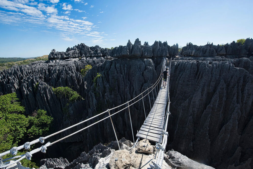
Tourism and Things to Do
- Grand Tsingy Circuit: The signature experience — suspension bridges, vertical ladders, permit-only access, exposed ridges with dramatic panoramas.
- Petit Tsingy Circuit: Shorter route suitable for moderately fit travelers with excellent canyon scenery.
- Manambolo River Canoe Journey: Drift through limestone walls, caves & ancient burial sites — quiet, surreal and unforgettable.
- Wildlife Spotting: Sifakas at dawn; geckos on warm limestone; owls at dusk — patience rewarded.
- Photography Expeditions: Rock needles at golden hour, lemurs leaping in silhouette, cathedral-like canyon interiors.
Travel here is **active, immersive and memory-defining** — more climb than safari, more exploration than sightseeing.
Access, Permits & Routes
Most visitors reach the region via **Morondava → Belo-sur-Tsiribihina → Bekopaka** using a reliable 4×4 vehicle. Two river ferry crossings are usually needed, and travel is easiest from **June to November** when the park is fully open. During rains, routes may close completely due to flooding or impassable mud.
All visitors must explore with a certified guide. Safety harnesses, helmets and via ferrata equipment are mandatory for Grand Tsingy circuits — and every step feels like a living adventure.
Accommodation & Where to Stay
Most lodging is based in **Bekopaka**, ranging from rustic bungalows to mid-range ecolodges. Some offer guided Tsingy excursions, canoe trips, night walks and photography outings. Camping is possible in designated zones with proper authorization, though the terrain remains rugged and minimal-impact.
The atmosphere is peaceful, remote and immersive — a genuine wilderness for travelers seeking discovery rather than luxury.
Best Time to Visit
The best period to explore Tsingy de Bemaraha is during the dry season (June–November). Trails are open, rock surfaces are safer, ferries run dependably and temperature remains comfortable for physical hiking. Early season (June–July) offers lush canyon vegetation post-rainfall, while late season (Sept–Nov) reveals crisp golden sunlight ideal for photography.
Rain season access is restricted, and Grand Tsingy circuits often close for safety — making advance planning essential.
Why Tsingy de Bemaraha Is Unmatched
Tsingy de Bemaraha is more than a national park — it is a living sculpture of geology and evolution. A stone forest where lemurs leap like gymnasts, where plants cling to razor edges, where rivers carve secret darkness into bright stone cathedrals. There is no other place like it, not in Africa, not in Madagascar, not anywhere.
To visit Tsingy is to witness Earth’s creativity with your own eyes — to explore a world designed by time, sharpened by rain, and guarded by limestone spires.