Mgahinga Gorilla National Park
Mgahinga Gorilla National Park – Mountain Gorillas, Golden Monkeys, Volcano Hiking and Uganda’s Sacred Virunga Highlands
Mgahinga Gorilla National Park is one of Africa’s most breathtaking highland sanctuaries—a compact but extraordinarily rich protected area located on the Ugandan side of the Virunga Mountains. Despite covering only 33.7 km², it contains soaring volcanic cones, deep montane forests, bamboo belts teeming with primates, Afro-alpine moorlands and some of the rarest wildlife found anywhere on the continent. It is one of the few places on Earth where visitors can trek endangered mountain gorillas in the morning, track golden monkeys in the afternoon and stand on the summit of a volcano overlooking three countries. This remarkable diversity of natural and cultural heritage makes Mgahinga one of Uganda’s most exceptional conservation landscapes and a premier destination for authentic gorilla and primate safaris.
The park forms part of the larger Virunga Conservation Area shared by Uganda, Rwanda and the Democratic Republic of Congo. Together, these transboundary parks protect over 450 km² of montane forest and high-altitude ecosystems that support mountain gorillas, golden monkeys, Rwenzori turacos, giant lobelias and a wealth of endemic species. Mgahinga is also the cultural homeland of the Batwa, an Indigenous community whose forest knowledge and spiritual traditions stretch back centuries. With its powerful combination of wildlife, mountains and culture, Mgahinga Gorilla National Park stands as a priceless wilderness jewel in the Albertine Rift.
Location, Size and Geographic Setting
Mgahinga Gorilla National Park lies in the Kisoro District of southwestern Uganda, bordering Rwanda’s Volcanoes National Park to the south and DR Congo’s Virunga National Park to the west. This location forms a seamless ecological corridor that allows wildlife to move freely across national boundaries—an essential feature for mountain gorillas, elephants and other wide-ranging species.
- Area: 33.7 km² (the smallest national park in Uganda).
- Elevation: Approximately 2,227 m to 4,127 m above sea level.
- Main features: The three Virunga volcanoes—Mt. Muhavura, Mt. Gahinga and Mt. Sabyinyo.
- Nearest town: Kisoro, 10 km away.
The park’s steep volcanic slopes create dramatic transitions in vegetation zones and sweeping views across the Albertine Rift Valley. On clear days, the peaks of the Virungas stretch into the horizon, while mist fills the gullies below. This high-altitude setting provides the ideal environment for mountain gorillas, golden monkeys, Afro-alpine plants and other rare species adapted to the cool, moist montane climate.
Geology, Volcanoes and Landscape Formation
The park’s landscape is defined by three dormant volcanic mountains, each formed millions of years ago due to intense tectonic activity along the Albertine Rift. The Virunga chain is one of the most striking volcanic groups in Africa, and Mgahinga protects the northern slopes of three of its iconic peaks.
- Mount Muhavura (4,127 m): The highest point in Mgahinga, known for its steep cone and a crater lake at the summit that reflects the sky like a volcanic mirror.
- Mount Gahinga (3,474 m): Characterized by its wide caldera, now filled with a swamp and surrounded by extensive bamboo forests.
- Mount Sabyinyo (3,669 m): A rugged, tooth-shaped volcano whose summit marks the exact border of Uganda, Rwanda and DR Congo—earning it the nickname “Old Man’s Teeth.”
Lava flows, ash deposits, volcanic caves and crater swamps provide evidence of the region’s turbulent geological past. Over centuries, these volcanic formations have created nutrient-rich soils that nurture lush montane vegetation. This geodiversity makes Mgahinga extraordinarily scenic and ecologically productive despite its small size.
Climate and Altitudinal Zonation
The climate of Mgahinga is cool and moist year-round due to its high elevation. Temperatures at the base of the park average around 20°C, while upper slopes can drop to near freezing at night—especially around the volcanic peaks. Mist often blankets the forest, creating the humid conditions preferred by gorillas and golden monkeys.
- Rainy seasons: March to May and September to November bring heavy rainfall and lush vegetation.
- Dry seasons: June to August and December to February offer the best conditions for trekking and hiking.
- Temperature range: 10°C to 23°C depending on altitude.
Altitudinal zonation is one of Mgahinga’s most striking ecological features. As visitors climb from the lower montane forest into the bamboo zone, then into Hagenia–Hypericum woodland and finally the subalpine moorlands, they experience a complete transformation of ecosystems comparable to moving across an entire continent.
Hydrology – Crater Lakes, Wetlands and Mountain Drainage
Although Mgahinga lacks large rivers, its hydrological importance cannot be overstated. The volcanic mountains act as crucial water towers for the densely populated Kisoro region. Frequent rainfall, fog condensation and natural springs feed numerous seasonal streams that descend from the slopes.
- Crater lakes: Mount Muhavura’s summit lake is one of the highest crater lakes in East Africa.
- Crater swamps: Mount Gahinga’s caldera supports unique wetland vegetation and amphibians.
- Seasonal streams: Runoff flows into local farming communities, supporting agriculture and domestic use.
- Forest sponge effect: Montane forests absorb rainfall and release it slowly, reducing erosion and stabilizing soils.
These hydrological features also support wildlife, creating microhabitats for frogs, insects, birds and small mammals in a park otherwise dominated by steep, forested slopes.
Ecosystems and Habitat Diversity
Mgahinga’s ecosystems are shaped entirely by altitude and volcanic topography. As one climbs, the vegetation changes in clearly defined belts, offering a natural demonstration of ecological zonation rare in most African parks.
- Lower Montane Forest (2,200–2,500 m): Evergreen trees, vines and ferns form the base of the park’s biodiversity.
- Bamboo Zone (2,500–3,000 m): A dense belt of bamboo that is essential for golden monkeys and a major seasonal food source for gorillas.
- Hagenia–Hypericum Woodland (3,000–3,400 m): Moss-covered branches, medicinal plants and gnarled trees thriving in constant mist.
- Subalpine Moorland (3,400–4,000+ m): Iconic giant lobelias, senecios and open Afro-alpine vegetation surrounding volcanic summits.
These habitats host flora and fauna adapted to cold temperatures, high moisture and reduced oxygen levels, making Mgahinga one of the most ecologically unique regions in East Africa.
Flora – Bamboo, Afro-Alpine Plants and Volcanic Vegetation
Mgahinga’s flora reflects its volcanic history and montane environment. The bamboo zone is particularly significant because it supports both the mountain gorillas and the golden monkeys. During bamboo shoots season, gorillas descend into this zone to feed on the soft, nutrient-rich shoots.
- Bamboo (Yushania alpina): The dominant vegetation type, forming thick forests preferred by golden monkeys.
- Hagenia abyssinica: A high-altitude tree often draped in moss and lichens.
- Giant lobelia and dendrosenecio: Afro-alpine plants found near summit ridges.
- Evergreen forest species: Including Syzygium, Podocarpus and Dombeya.
In addition to its beauty, Mgahinga’s flora supports a variety of traditional medicinal practices known to the Batwa, whose mastery of forest plants is unrivaled in the region.
Wildlife of Mgahinga Gorilla National Park
Mgahinga is renowned for its primates, but its steep volcanic slopes also host antelope, forest elephants, rare birds, amphibians and small mammals. Its biodiversity is amplified by the fact that animals move freely between Uganda, Rwanda and DR Congo.
Mammals
The park supports over 39 mammal species, many of which are adapted to high-altitude forests and bamboo zones. Key species include:
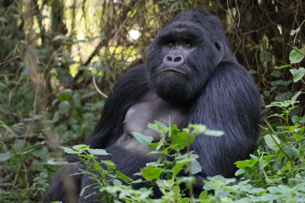
- Mountain gorillas: The Nyakagezi gorilla group is the park’s habituated family, known for its calm interactions with tourists.
- Golden monkeys: Endemic to the Virunga Mountains and one of Africa’s most photogenic primate species.
- Forest elephants: Occasionally move through Mgahinga along transboundary corridors.
- Black-fronted duiker: A shy forest antelope adapted to montane environments.
- Buffalo, bushbuck and giant forest hog: Found in lower forest areas.
Mountain Gorillas – The Heart of Mgahinga
The highlight of Mgahinga is trekking to see the famous mountain gorillas. The Nyakagezi group has a history of roaming across Uganda, Rwanda and DR Congo, but in recent years has remained mostly within Uganda, offering reliable tracking opportunities. Gorilla trekking typically involves hiking through dense forest, bamboo belts and volcanic slopes to locate the group, guided by experienced rangers and trackers.
Gorilla encounters in Mgahinga are intimate and unforgettable, with small group sizes, quiet forests and dramatic scenery enhancing the experience.
Golden Monkeys – Endemic Jewels of the Virunga
Golden monkeys are another of Mgahinga’s star attractions. Their striking golden-orange fur, agile movement and playful behavior make them a delight to track. They live primarily in the bamboo zone, feeding on bamboo shoots, leaves, fruits and insects. Mgahinga offers both regular tracking and an immersive golden monkey habituation experience, where visitors spend extended time with researchers and monkeys.
Birdlife
Mgahinga is exceptionally rich in birdlife for its size, with over 180 species recorded. Many of these species are Albertine Rift endemics—birds found nowhere else in the world.
- Ruwenzori turaco: A brilliantly colored species seen gliding through forest canopies.
- Kivu ground thrush and Rwenzori batis: Montane forest specialists.
- Striped breasted tit: Found in higher elevations.
- White-starred robin: Common along forest trails.
Birding in Mgahinga is rewarding during all seasons, but especially after rains when insect life flourishes.
Reptiles, Amphibians and Insects
Mgahinga’s cool, moist climate supports amphibians such as the Ruwenzori toad, tree frogs and high-altitude frog species. Reptiles include three-horned chameleons, skinks and forest snakes. Insects flourish in the understory: butterflies feed on flowering plants, beetles inhabit rotting logs and moths thrive in the misty forest microclimates.
Cultural Heritage – The Batwa People
The Batwa are the original inhabitants of the forests surrounding Mgahinga, living as hunter-gatherers for centuries before the creation of the national park. Their deep spiritual connection to the forest, extensive ecological knowledge and traditional skills make them an integral part of Mgahinga’s cultural landscape.
- The Batwa Cultural Trail: A guided experience showcasing hunting techniques, herbal medicine, cave traditions and music.
- Garama Cave: A historic site used as a meeting place and refuge by Batwa leaders.
- Traditional tools: Demonstrations of fire-making, basket weaving and storytelling.
This trail is essential for understanding the human history of the Virunga region and the cultural importance of the forests that Mgahinga protects.
Conservation Importance
Mgahinga’s conservation value is immense, especially as mountain gorillas remain one of the world’s most endangered primates. The park contributes to a broader transboundary conservation strategy that protects the entire Virunga Mountain ecosystem.
- Critical habitat for mountain gorillas, golden monkeys and Albertine Rift endemics.
- Carbon-rich montane forests that help mitigate climate change.
- Important water catchment for southwestern Uganda.
- Corridor for elephants and other wide-ranging wildlife.
Revenue from gorilla trekking also supports local communities and strengthens conservation efforts throughout the region.
Threats and Environmental Challenges
- Human encroachment: Farmland expansion around park boundaries.
- Climate change: Affecting Afro-alpine vegetation and species ranges.
- Poaching and illegal resource use: Largely reduced but historically significant.
- Cross-border pressures: Wildlife movement across Rwanda and DR Congo requires continuous collaboration.
Continuous monitoring, community engagement and international cooperation help mitigate these threats.
Research and Monitoring Programs
Mgahinga is a scientific hotspot for studying montane ecosystems, primates and volcanic environments. Ongoing research helps improve conservation strategies and protect rare species.
- Gorilla monitoring: Tracking group composition, births, movements and health.
- Golden monkey studies: Behavior, feeding patterns and troop dynamics.
- Vegetation surveys: Monitoring effects of climate change on Afro-alpine plants.
- Batwa cultural documentation: Recording oral histories and traditional ecological knowledge.
These research efforts maintain Mgahinga’s position as a key conservation and scientific research area in the Albertine Rift.
Tourism Activities in Mgahinga Gorilla National Park
- Gorilla Trekking: A once-in-a-lifetime experience with the Nyakagezi gorilla family.
- Golden Monkey Tracking: One of the best places in Africa to see this endemic species.
- Volcano Hiking: Summit Mt. Muhavura, Mt. Gahinga or Mt. Sabyinyo for panoramic views.
- Batwa Cultural Trail: Authentic cultural experience with the Indigenous Batwa community.
- Birdwatching: Superb for Albertine Rift endemics.
- Nature Walks: Scenic trails through volcanic scenery and forested slopes.
Access – How to Reach Mgahinga Gorilla National Park
- By Road: 8–10 hours from Kampala, 1–2 hours from Kisoro, depending on conditions.
- By Air: Domestic flights from Entebbe to Kisoro Airstrip.
- Regional Access: Easily reached from Musanze (Rwanda) via the Cyanika border.
Permits and Park Regulations
- Gorilla trekking permit: Required and issued by the Uganda Wildlife Authority.
- Golden monkey permit: Separate permit needed for tracking or habituation.
- Maintain a safe distance from wildlife.
- Stay on designated trails.
- Minimum trekking age applies.
Accommodation Options
- Mount Gahinga Lodge: The most luxurious option near the park, with volcanic views.
- Mid-range lodges: Options in Kisoro such as Traveller’s Rest and Lake Chahafi lodges.
- Budget accommodations: Community-run campsites and lodges.
Many lodges offer stunning panoramic views of the volcanoes and easy access to park gates.
Best Time to Visit Mgahinga Gorilla National Park
- June–August: Clear skies and excellent trekking conditions.
- December–February: Another peak period with favorable weather.
- March–May & September–November: Wet seasons with lush scenery and vibrant birdlife.
Dry seasons are ideal for trekking and volcano hiking, while wet seasons offer quieter trails and dramatic landscapes.
Why Mgahinga Gorilla National Park Is Unique
Mgahinga Gorilla National Park offers an extraordinary blend of gorilla trekking, golden monkey encounters, rich Batwa cultural heritage and spectacular volcano hiking—all within a compact and easily navigable landscape. Its high-altitude ecosystems, dramatic volcanic scenery and cross-border wildlife movement make it unlike any other park in East Africa. Mgahinga is not just a national park; it is a mountain kingdom where biodiversity, culture and geography combine to create one of the most unforgettable safari destinations in Uganda.
From standing at the tri-border summit of Mt. Sabyinyo to meeting the Nyakagezi gorillas in a mist-covered forest, every moment in Mgahinga is filled with magic, adventure and a profound connection to one of the world’s most remarkable natural environments.